
Walk a Bell County Street by Address
A street search works best as a dated chain. First confirm the complete delivery line with the USPS address lookup. Then locate the parcel and keep its identifiers with the original street spelling. Bell County has duplicated street names, shared ZIP codes, rural routes, installation addresses, and multi-unit locations. A search that drops a direction, unit, or postal place can join records from different places.
- Search the exact situs in Bell CAD, then record the Property ID, Geographic ID, legal description, subdivision, block, lot, tax year, and the separate situs and mailing fields.
- Use the parcel geometry, street, road, structure, city-limit, and flood-hazard layers at Killeen GIS when the address is within its public map area. The map supplies location context, not a deed.
- Search the same legal description, subdivision, grantor, grantee, and date range in the Bell County official-records portal. Inspect the instrument image or request a certified copy when title-level proof is needed.
- For civic geography, compare the Bell Elections precinct resources and Texas My Voter Portal. Treat a registration result as status information at a point in time, not proof that a person occupies the parcel.
- For an older address, pair a dated directory, census, map, or newspaper with the parcel and deed trail. The historical volumes are discussed in the Bell County city directory collection reference.
Keep the source date beside every result. A tax-roll owner, a recorded grantee, a directory entry, and an actual occupant are different facts. The address reference becomes useful when it reports those roles plainly instead of merging them.
Bell County Street Directory Starting Points
Use the printed form first, then make a normalized form for searching. Separate the house number, direction, street name, street type, suffix, unit, city, ZIP, and any rural-route or post-office notation. Retain the original spelling. A deed can preserve a form that a modern map does not recognize, and a street type such as FM, Loop, Highway, Road, or Avenue should not be assumed equivalent without a map or agency confirmation.
When the street line fails, the stable pivot is usually the land description. Bell records can be searched by subdivision, phase, block, lot, section, abstract, survey, tract, map ID, Geographic ID, or Property ID. This is especially helpful when a new subdivision, municipal boundary, or older route name complicates a simple address query. Store failed variations too, because a no-result screen may reflect a spelling or coverage gap rather than the absence of a record.
- Parcel
- A mapped tract used in appraisal and land records. One parcel may hold more than one unit or none at all.
- Situs address
- The physical location carried on a property record. It is separate from the address where tax notices are sent.
- Plat
- A recorded map that lays out lots, streets, easements, or subdivisions. It can bridge a legal tract to a later street pattern.
- Criss-cross directory
- An address-first directory arrangement that may place a dated listing under a street address rather than under a surname.
Bell CAD Fields for a Bell County Street
Bell Central Appraisal District is the county appraisal source, not a current-occupancy register or a final title source. Its property search accepts owner, address, ID, and advanced property queries. Start broadly enough to find the parcel, then narrow with its Property ID or Geographic ID. The sample card joins a property identifier to a legal lot and also shows valuation, exemption, roll-history, and deed-history areas, which makes it a practical street-directory pivot.
| Bell CAD field | Street-directory use | Limit to retain |
|---|---|---|
| Owner display | Names the appraisal record holder for that card. | It can identify an individual, trust, estate, business, or multiple parties. |
| Situs and mailing address | Separates the parcel location from the tax-bill destination. | Neither field alone establishes a person’s presence at the parcel. |
| Property ID and Geographic ID | Provides stable keys for an official-record request or map comparison. | Copy each exactly before moving to another system. |
| Legal description and subdivision | Supports a deed, plat, lot, block, abstract, or survey search. | Use the document image to verify how the term appears in an instrument. |
| Roll and deed-history areas | Offers dates and leads for the next records search. | Appraisal history is not a complete chain of title. |
The Bell CAD sample property card shows why address research needs field labels. Its owner display, situs, legal description, value, exemptions, roll history, and deed-history tables are presented for appraisal work. Read the card as a collection of labeled, dated property fields.
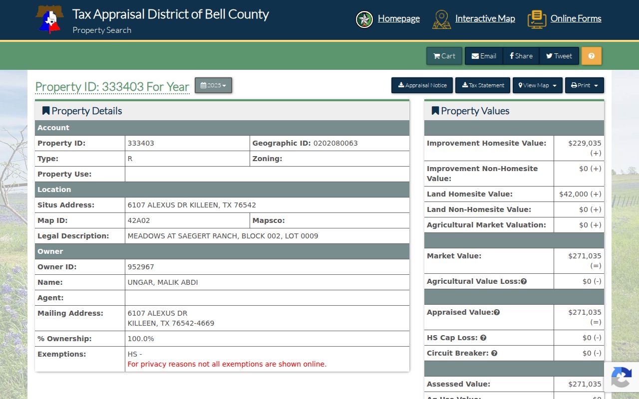
Using the Property ID and legal description from a card is safer than trying to carry a loose street-name match into the recorded-instrument index.
Killeen GIS on Bell County Streets
Killeen’s public MapServer documents parcel, road, city-limit, structure, park, council-district, and flood-hazard context. Parcel-layer fields include PROP_ID, PRIMARYADDRESS, legal description, subdivision, abstract, and owner display. Use those fields to compare a map result with Bell CAD, not to substitute the map for the appraiser’s record or a survey.
The service area matters. A Killeen mailing address may sit near Harker Heights or unincorporated Bell County, and Fort Hood and postal-city conventions add another layer. Compare city limits, the parcel, USPS delivery result, and the county election map before assigning a municipal custodian. GIS geometry can be generalized or updated, so record the layer date or metadata when it is shown.
Note: Parcel maps provide spatial context, while recorded instruments and surveys control the legal details of a tract.
Bell County Street Records by Address
Several Bell County sources can be keyed to an address, but each answers a narrower question. Use the table as a coverage map, not as a list of people along a street. The correct order is parcel first, record role second, and date third. If an online path does not supply the needed record, the research fallback is the county or city custodian, a specific Texas Public Information Act request, or an on-site historical repository.
| Address-keyed source | Custodian | What it can show | Access path |
|---|---|---|---|
| Property card and roll | Bell CAD | Owner display, situs, mailing address, legal description, exemptions, and appraisal history. | Free property portal; district contacts handle appraisal records. |
| Parcel and civic layers | Killeen GIS and Bell Elections | Parcel geography, roads, city limits, structures, precinct and related service geography. | Public viewers, limited to their layers and service areas. |
| Recorded instruments | Bell County Clerk | Deeds, plats, liens, releases, easements, and other dated instrument metadata. | Free index discovery, image or copy steps may carry charges. |
| Permit, address-assignment, or CO file | Relevant city department | Address assignment, construction, final inspection, and permitted-use history. | City portal when offered, otherwise a narrow request for an existing record. |
| Historic household material | TSLAC, Museum, BCHC, and archives | Dated directory, map, census, newspaper, or obituary context. | Reading-room, repository, copy-request, or digital-collection access. |
Bell County Clerk requests can be sent by mail, email, hand delivery, or approved fax/web route under the Texas Public Information Act. Identify the department, record type, property or document identifier, and date range. Ask to inspect existing records if copies are not needed. An agency does not have to create a new street-by-street compilation.
Bell County Deed Filters for Street History
The official-record application offers two useful scopes. Index Only searches names, document types, subdivisions, and recorded metadata. Index & Full Text searches OCR from images, but OCR can misread names and legal descriptions, and image access can involve additional steps. Record which scope was searched, because an index-only miss does not show that an image lacks the word.
The advanced official-records search provides party, date, document number, book, volume, page, legal-description, subdivision, section, condominium, and image-text filters. Search grantor and grantee separately, then search the legal description. A grantor transfers an interest, while a grantee receives one. A deed of trust, release, lien, plat, or easement has its own meaning and should not be read as a simple ownership statement.
The public quick search is illustrated at the Bell County official-records source. It is a starting point for a street search, not proof of a complete or current address history.
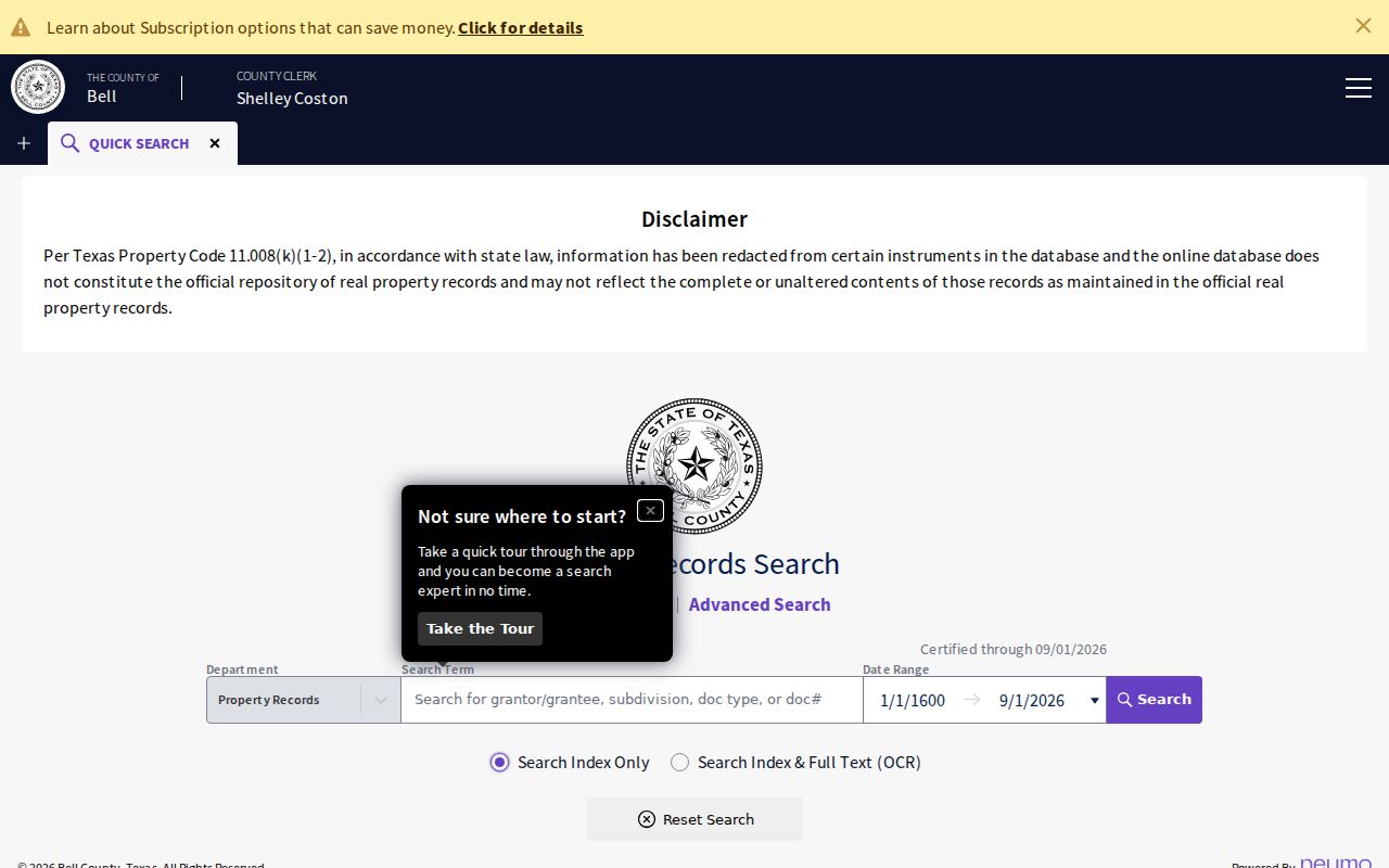
Save the document number, recording date, party role, legal description, and image status with any result so a later record request can be specific.
ZIP, City Limits, and Bell County Streets
Postal geography must be kept apart from legal geography. ZIP codes 76542, 76543, and 76548 overlap Killeen and Harker Heights; 76544 has Fort Hood and military-postal context; 76513 includes Belton and Morgan’s Point Resort context. A postal city line is useful for delivery, but it cannot settle city-limit status, county jurisdiction, precinct, or the correct local records office.
Use USPS for delivery geography, Bell CAD and a parcel layer for the situs, and the election map for precinct context. Census ZIP Code Tabulation Areas are statistical areas, not exact USPS ZIP boundaries. For a historical line, retain three columns in the research log: the original address as printed, the normalized search string, and the interpretation or unresolved uncertainty.
Note: A PO Box, rural route, unit omission, or military mailing line requires its own source label before it is compared with a parcel.
Bell County Voter Geography by Street
Bell Elections links current voter resources, precinct maps, and an ArcGIS map for precinct, commissioner, justice-of-the-peace, and WCID geography. The Texas My Voter Portal supports lookup by VUID, Texas driver license or ID, or first and last name, with county registrar help. These access paths are appropriate for a permitted individual status question, not for republishing identifiers or creating a street roster.
A registration result can confirm a voter-status or precinct fact on the date checked. It cannot establish that a tax-card owner, a deed party, or a directory listing is the same person. Texas guidance treats Social Security numbers, Texas driver-license and DPS personal-ID information as confidential, and protected participants can have residence information suppressed. Where geography is all that is needed, use the precinct map instead of seeking personal information.
Historic Street Clues in Bell County
Older Bell County addresses require a mixed source trail. The Library of Congress holds an April 1893 Temple Sanborn set with eight sheets, while Texas State Library and Archives holdings include Temple directories from 1911 through selected later years and Killeen directories for 1963, 1982, and 1990. Those sources record buildings and dated listings, not a continuous roll of every person on every street.
Temple’s digitized newspaper collection has 4,628 items, largely from the 1900s through the 1920s. Search a street name with variant surnames, property notices, or civic events, then verify the date and place. Bell County Museum and the Historical Commission keep in-house and historical materials that can fill an online gap. A directory or newspaper listing should remain exactly that, with its year and page, rather than becoming an unsupported current claim.
Bell County Address Requests and Permits
A permit or certificate-of-occupancy file can explain why an address appears late in the record trail. Bell County research found no one uniform public permit interface for every city. Start with the relevant city’s building or records route, then request the narrow existing file: permit number, address assignment, final inspection, certificate of occupancy, structure, demolition, zoning, or code case. Avoid asking an office to infer people connected to an address.
For recorded land material, direct a request to the Bell County Clerk property-recording department and include the Property ID or Geographic ID, legal description, situs, date range, and instrument types. The Clerk distinguishes property recording from civil/probate, criminal, and vital-statistics functions. That specificity reduces misrouting and gives staff a way to identify fees before copies are made.
Bell County Street Search Privacy Limits
Address research cannot establish a complete household list. An appraisal owner may receive tax mail elsewhere, an instrument party may have a limited legal role, a parcel can contain multiple units or no structure, and a historic source only supports its own date. Birth and death access limits, juvenile confidentiality, protected voter records, and redacted court information remain in force even when another address-related record is public.
When the official index is incomplete or a field is protected, report that limitation directly. The Texas Public Information Act, Government Code chapter 552, provides a route for specific existing public records, but it does not require a custodian to disclose confidential material or produce a new directory from separate files.
Why a Bell County Street Match Can Conflict
Conflicts are normal in an address trail. Bell CAD can lag a new deed, a deed can be recorded after it was signed, and a mailing address can change without a parcel move. Killeen GIS is valuable for spatial context but is not a survey or legal priority source. A directory may identify a dated household listing while an instrument identifies a nonresident owner. Keep both facts and label each source, date, field, and role.
For a land-history question, confidence rises when the parcel ID and legal description match across sources. A shared surname and street name is weaker. If the chain cannot bridge an old address to a current parcel, retain the gap rather than forcing a match. That discipline makes the Bell County address reference more useful for lawful research and less likely to misstate a connection.